Fries, Virginia | |
|---|---|
 Downtown Fries, 2012 | |
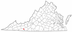
 Location of Fries, Virginia | |
| Coordinates: 36°42′56″N 80°58′33″W / 36.71556°N 80.97583°W | |
| Country | United States |
| State | Virginia |
| County | Grayson |
| Area | |
| • Total | 0.82 sq mi (2.13 km2) |
| • Land | 0.64 sq mi (1.65 km2) |
| • Water | 0.18 sq mi (0.48 km2) |
| Elevation | 2,185 ft (666 m) |
| Population | |
| • Total | 452 |
| • Estimate (2021)[2] | 451 |
| • Density | 699.06/sq mi (269.98/km2) |
| Time zone | UTC−5 (Eastern (EST)) |
| • Summer (DST) | UTC−4 (EDT) |
| ZIP code | 24330 |
| Area code | 276 |
| FIPS code | 51-29920[3] |
| GNIS feature ID | 1483549[4] |
| Website | Official website |
Fries (pronounced "freeze") is an incorporated town located on the New River in Grayson County, Virginia, 15.5 miles (24 kilometers) northeast of the county seat in Independence — in Virginia's Blue Ridge Highlands and on Virginia's musical heritage trail, The Crooked Road.
Named after prominent cotton mill owner, Francis Henry Fries, the town is noted as the former site of Washington Mill (1903-1989); as one of three end points of the New River Trail State Park and as the host of annual music festivals reflecting its strong bluegrass and country music traditions — with its August Old-Time Fiddlers' and Bluegrass Convention and its September Festival by the New River.[5]
- ^ "2019 U.S. Gazetteer Files". United States Census Bureau. Retrieved August 7, 2020.
- ^ a b "City and Town Population Totals: 2020—2021". Census.gov. US Census Bureau. Retrieved October 7, 2022.
- ^ "U.S. Census website". United States Census Bureau. Retrieved January 31, 2008.
- ^ "US Board on Geographic Names". United States Geological Survey. October 25, 2007. Retrieved January 31, 2008.
- ^ Fussell, pgs. 74 - 74