| Front Range | |
|---|---|
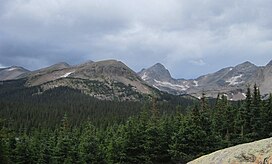
 Front Range Peaks in the Indian Peaks Wilderness | |
| Highest point | |
| Peak | Grays Peak |
| Elevation | 14,278 ft (4,352 m) |
| Coordinates | 39°38′02″N 105°49′01″W / 39.63389°N 105.81694°W |
| Geography | |
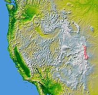
 The Front Range (excluding the Laramie Mountains) is shown highlighted on a map of the western U.S. | |
| Country | United States |
| States |
|
| Parent range | Rocky Mountains |
The Front Range is a mountain range of the Southern Rocky Mountains of North America located in the central portion of the U.S. State of Colorado, and southeastern portion of the U.S. State of Wyoming.[1] It is the first mountain range encountered as one goes westbound along the 40th parallel north across the Great Plains of North America.
The Front Range runs north-south between Casper, Wyoming, and Pueblo, Colorado, and rises nearly 10,000 feet above the Great Plains. Longs Peak, Mount Blue Sky, and Pikes Peak are its most prominent peaks, visible from the Interstate 25 corridor. The area is a popular destination for mountain biking, hiking, climbing, and camping during the warmer months and for skiing and snowboarding during winter. Millions of years ago, the present-day Front Range was home to ancient mountain ranges, deserts, beaches, and even oceans.[2]
The name "Front Range" is also applied to the Front Range urban corridor, the populated region of Colorado and Wyoming just east of the mountain range and extending from Cheyenne, Wyoming south to Pueblo, Colorado. This urban corridor benefits from the weather-moderating effect of the Front Range mountains, which help block prevailing storms.
- ^ "GNIS Feature Search". Archived from the original on 2012-07-14. Retrieved 2010-05-13. |U.S. Geological Survey confirms that the Laramie Mountains(range) are the northern extent of the Front Range.
- ^ Johnson, Kirk R.; et al. (2006). Ancient Denvers. Fulcrum Publishing. ISBN 978-1-55591-554-4.