Frontenac Islands | |
|---|---|
| Township of Frontenac Islands | |
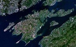
 Satellite view of Frontenac Islands, with Wolfe Island being the largest | |
| Coordinates: 44°12′N 76°23′W / 44.200°N 76.383°W | |
| Country | |
| Province | |
| County | Frontenac |
| Incorporated | 1998 |
| Government | |
| • Type | Township |
| • Mayor | Judith Anne Greenwood-Speers |
| • Federal riding | Kingston and the Islands |
| • Prov. riding | Kingston and the Islands |
| Area | |
| • Land | 175.04 km2 (67.58 sq mi) |
| Population (2016)[2] | |
| • Total | 1,760 |
| • Density | 18.5/km2 (48/sq mi) |
| Time zone | UTC-5 (EST) |
| • Summer (DST) | UTC-4 (EDT) |
| Postal Code | K0H |
| Area code(s) | 613, 343 |
| Website | http://www.frontenacislands .ca |

Frontenac Islands is a township located in Frontenac County, Ontario, Canada, that encompasses a number of islands at the beginning of the Saint Lawrence River near the outlet of Lake Ontario, including: Arabella, Bayfield, Black Ant, Garden, Goose, Hickory, Horseshoe, Howe, Wolfe, and Simcoe.[citation needed]
The township was formed in 1998 when Howe Island Township and Wolfe Island Township were merged as part of the county's reorganization.
- ^ Cite error: The named reference
SC11was invoked but never defined (see the help page). - ^ "Census Profile, 2016 Census: Frontenac Islands, Township". Statistics Canada. 8 February 2017. Retrieved June 13, 2019.
