Fukang
| |
|---|---|
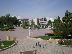
 Central square in Fukang City | |
 Location of Fukang (red) in Changji Prefecture (yellow) and Xinjiang | |
| Coordinates: 44°09′53″N 87°57′13″E / 44.1646°N 87.9536°E | |
| Country | China |
| Autonomous region | Xinjiang |
| Autonomous prefecture | Changji |
| Township-level divisions |
|
| Municipal seat | Bofeng Subdistrict |
| Area | |
| • Total | 11,726 km2 (4,527 sq mi) |
| Population (2020)[1] | |
| • Total | 181,144 |
| • Density | 15/km2 (40/sq mi) |
| Time zone | UTC+8 (China Standard[a]) |
| Website | www |
| Fukang | |||||||||||
|---|---|---|---|---|---|---|---|---|---|---|---|
| Chinese name | |||||||||||
| Chinese | 阜康 | ||||||||||
| |||||||||||
| Uyghur name | |||||||||||
| Uyghur | فۇكاڭ | ||||||||||
| |||||||||||
Fukang[2] is a county-level city in Xinjiang Uygur Autonomous Region, China. Its area is 11,726 km2 (4,527 sq mi) and its population in 2007 was reported as approximately 1.5 million.[3] Fukang is located in Northern Xinjiang in Changji Hui Autonomous Prefecture, north of Ürümqi.
- ^ Xinjiang: Prefectures, Cities, Districts and Counties
- ^ "فۇكاڭ: China". Geographical Names. Retrieved 2011-02-19.
- ^ "Fukang Overview". Fukang Government. Archived from the original on 2011-07-07. Retrieved 2011-02-19.
Cite error: There are <ref group=lower-alpha> tags or {{efn}} templates on this page, but the references will not show without a {{reflist|group=lower-alpha}} template or {{notelist}} template (see the help page).

