Fusui County
扶绥县 · Fuzsuih Yen | |
|---|---|
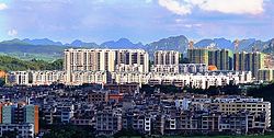
 The eponymous county seat of Fusui | |
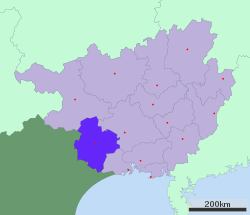
 Fusui is the easternmost division in this map of Chongzuo | |
 Chongzuo in Guangxi | |
| Coordinates: 22°38′06″N 107°54′15″E / 22.6350°N 107.9042°E | |
| Country | China |
| Autonomous region | Guangxi |
| Prefecture-level city | Chongzuo |
| Township-level divisions | 8 towns 3 townships |
| County seat | Xinning (新宁镇) |
| Area | |
• Total | 2,876 km2 (1,110 sq mi) |
| Elevation | 94 m (309 ft) |
| Population (2020) | |
• Total | 408,921 |
| • Density | 140/km2 (370/sq mi) |
| Time zone | UTC+8 (China Standard) |
| Postal code | 532200 |
| Website | https://web.archive.org/web/20110513115806/http://www.gxfs.gov.cn/ |
| Fusui | |||||||||
|---|---|---|---|---|---|---|---|---|---|
| Chinese name | |||||||||
| Traditional Chinese | 扶綏 | ||||||||
| Simplified Chinese | 扶绥 | ||||||||
| |||||||||
| Zhuang name | |||||||||
| Zhuang | Fuzsuih | ||||||||
Fusui County is a county in the southwest of Guangxi, China. It is the easternmost county-level division of the prefecture-level city of Chongzuo.