Galibi | |
|---|---|
 Turtle on the beach of Galibi | |
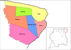
 Map showing the resorts of Marowijne District. Galibi | |
| Coordinates: 5°41′52″N 54°01′40″W / 5.6978°N 54.0277°W | |
| Country | |
| District | Marowijne District |
| Area | |
| • Total | 1,014 km2 (392 sq mi) |
| Elevation | 0 m (0 ft) |
| Population (2012)[1] | |
| • Total | 741 |
| • Density | 0.73/km2 (1.9/sq mi) |
| Time zone | UTC-3 (AST) |
Galibi is a resort in Suriname, located in the Marowijne District. Its population at the 2012 census was 741. Galibi is a tribal area inhabited by an indigenous population[1] of Kalina Amerindians.[2]
The town of Alusiaka used to be located near the banks of the Marowijne River. The Dutch West India Company was given 500 hectares to grow coconuts; but, because of their mistreatment of the workers, the town was abandoned.[3] In 1871 a 60-metre lighthouse was built near the entrance of the Marowijne; it was operated until 2012.[4]
- ^ a b "Resorts in Suriname Census 2012" (PDF). Retrieved 21 May 2020.
- ^ "Dorpen en Dorpsbesturen". Vereniging van Inheemse Dorpshoofden (in Dutch). Retrieved 25 February 2021.
- ^ "Een geschiedenis van de Surinaamse literatuur. Deel 2". Digital Library for Dutch Literature (in Dutch). 2002. Retrieved 21 May 2020.
- ^ Rowlett, Russ. "Lighthouses of Suriname". The Lighthouse Directory. University of North Carolina at Chapel Hill. Retrieved 21 May 2020.