| Galien River | |
|---|---|
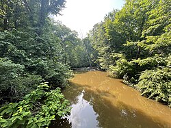
 Galien River looking downstream from Warren Woods State Park trail bridge in August 2023. | |
| Location | |
| Country | United States |
| State | Michigan |
| Region | Berrien County |
| Physical characteristics | |
| Source | Dayton Lake |
| • location | East of Galien, Michigan, Berrien County, Michigan, United States |
| • coordinates | 41°47′47″N 086°26′33″W / 41.79639°N 86.44250°W[1] |
| • elevation | 720 ft (220 m) |
| Mouth | Lake Michigan |
• location | New Buffalo, Berrien County, Michigan |
• coordinates | 41°48′04″N 086°44′57″W / 41.80111°N 86.74917°W[1] |
• elevation | 581 ft (177 m)[1] |
| Discharge | |
| • location | mouth |
| • average | 213.53 cu ft/s (6.046 m3/s) (estimate)[2] |
| Basin features | |
| Tributaries | |
| • left | Dowling Creek, South Branch Galien River |
| • right | Blue Jay Creek, East Branch Galien River, Kirktown Creek |
The Galien River/ɡɑːˈliːn/ is a 30.0-mile-long (48.3 km)[3] stream in the southwest region of the U.S. state of Michigan. The river begins at the outlet of Dayton Lake and flows in a predominantly westerly direction until it enters southeastern Lake Michigan at New Buffalo. The South Branch Galien River rises just north of the border with Indiana, at the confluence of Spring Creek and the Galena River, the latter rising in LaPorte County, Indiana.[4][5]
- ^ a b c U.S. Geological Survey Geographic Names Information System: Galien River
- ^ United States Environmental Protection Agency. "Watershed Report: Galien River". WATERS GeoViewer. Archived from the original on 2021-08-25. Retrieved 2021-08-25.
- ^ U.S. Geological Survey. National Hydrography Dataset high-resolution flowline data. The National Map, accessed May 19, 2011 Archived March 29, 2012, at the Wayback Machine
- ^ U.S. Geological Survey Geographic Names Information System: Galena River
- ^ U.S. Geological Survey Geographic Names Information System: South Branch Galien River