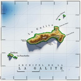
 Topographic map of La Galite | |
| Geography | |
|---|---|
| Location | Mediterranean Sea |
| Coordinates | 37°31′37″N 08°55′43″E / 37.52694°N 8.92861°E |
| Total islands | 6[1] |
| Major islands | La Galite (5.4 km2) Le Galiton La Fauchelle |
| Area | 8.08 km2 (3.12 sq mi) |
| Highest point | Bout de Somme (391 m) |
| Administration | |
| Governorate | Bizerte Governorate |

The Galite Islands (Tunisian Arabic: جالطة Jalita, French: La Galite, Italian: La Galita) are a rocky group of islands of volcanic origin that belong to Bizerte Governorate, northern Tunisia. They are located 38 kilometres (24 miles) northwest of Cape Serrat, the closest point of the Tunisian mainland coast, from which they are separated by the Galite Channel, and almost 80 km (50 mi) north-by-northeast of the city of Tabarka, and 150 km (93 mi) south of Cape Spartivento in the south of Sardinia. The islands of the group sit atop Banc de Galite.

- ^ Plus some reefs and a submerged group
