| Galunggung | |
|---|---|
| Gunung Galunggung | |
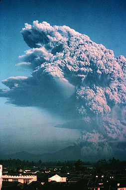
 Galunggung eruption in 1982 | |
| Highest point | |
| Elevation | 2,168 m (7,113 ft) |
| Listing | Ribu |
| Coordinates | 7°15′24″S 108°04′37″E / 7.2567315°S 108.0770588°E |
| Geography | |
| Location | West Java, Indonesia |
| Geology | |
| Mountain type | Stratovolcano |
| Last eruption | January 1984[1] |
Mount Galunggung (Indonesian: Gunung Galunggung, formerly spelled Galoen-gong, Sundanese: ᮌᮥᮔᮥᮀ ᮍᮜᮥᮀᮍᮥᮀ) is an active stratovolcano in West Java, Indonesia, around 80 km (50 mi) southeast of the West Java provincial capital, Bandung (or around 20 km (12 mi) to the northwest of the West Java town of Tasikmalaya). Mount Galunggung is part of the Sunda Arc extending through Sumatra, Java and the Lesser Sunda Islands, which has resulted from the subduction of the Australian Plate beneath the Eurasian Plate.
For the first time since 1982 after eruptions finished and conditions seemed normal, on February 12, 2012, the status was upgraded to Alert based on changes in conditions.[2] [3] On 28 May 2012, it was lowered from 2 back to 1 (On a scale of 1–4).
- ^ "Galunggung". Global Volcanism Program. Smithsonian Institution. Retrieved 2021-06-24.
- ^ "Sejak 1982, Baru Kali ini Galunggung Berstatus Waspada (in Indonesian)". February 14, 2012. Archived from the original on September 7, 2012.
- ^ Suwarni, Yuli Tri (February 13, 2012), "Mt. Galunggung status raised to alert", The Jakarta Post, archived from the original on February 14, 2012
