Gangnam
| |
|---|---|
|
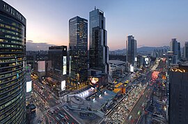
Left to right from top: Intersection in Teheran Valley, Samsung Town, Bongeunsa temple, Lotte World Tower, Gangnam nightlife, Gangnam skyline | |
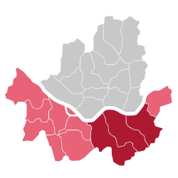
 Districts in dark red are traditionally considered part of Gangnam, while districts in pink are sometimes considered part of Gangnam | |
| Country | |
| Metropolitan Area | Seoul Capital Area |
| City | Seoul |
| Composition | Core Periphery |
| Area | |
| • Total | 307.34 km2 (118.66 sq mi) |
| • Core | 120.26 km2 (46.43 sq mi) |
| Population (2020) | |
| • Total | 4,985,421 |
| • Core | 1,553,172 |
Gangnam (Korean: 강남; Hanja: 江南; lit. South of the [Han] River; IPA: [ka̠ŋna̠m]), sometimes referred to as the Greater Gangnam Area, is a geographic and cultural region in Seoul. While Gangnam can refer to the entire region of Seoul south of the Han River, the region is generally defined as consisting of the city's affluent Gangnam, Seocho and Songpa districts.[a] Other definitions define Gangnam by the boundaries of the Gangnam Eighth School District[1] or by the commercial zones around Gangnam Highway, Yangjae Station,[2] Sinsa Station,[3] Nonhyeon Station, Sinnonhyeon Station[4] and Gangnam station.[5] These definitions exclude the Songpa District, which has been argued to be culturally and administratively distinct from the Gangnam and Seocho districts.
Historically, the region was also called Yeongdong (영동; 永東; lit. East of Yeongdeungpo) and remained undeveloped prior to the state-led urban development of the 1960s.[6] During the 1970s and 1980s, Park Chung Hee, aiming to counteract urban sprawl and the threat of North Korean invasion, promoted development in Gangnam through targeted investment into the region and the suppression of development north of the Han River. As the result of Park's policies, a number of companies, prestigious schools, and government institutions relocated to the region and land prices in Gangnam skyrocketed.
Cite error: There are <ref group=lower-alpha> tags or {{efn}} templates on this page, but the references will not show without a {{reflist|group=lower-alpha}} template or {{notelist}} template (see the help page).
- ^ 명문고 강남 이전과 평준화 정책이 만든 '8학군병'. SBS 뉴스 (in Korean). December 26, 2015. Retrieved December 19, 2023.
- ^ 강남구청. 강남구 "양재역 환승센터에 도곡 방향 출구 개설돼야" | 강남구청 > 강남소식 > 보도자료 > 보도자료. 강남구청 (in Korean). Retrieved December 26, 2023.
- ^ 서초구,'잠원 간장게장 골목'에 뉴트로 감성 담아 상권 활성화. 4차산업행정뉴스 (in Korean). Retrieved December 19, 2023.
- ^ 서초구, 강남~신논현역에 보행 혼잡도 표시 전광판 2곳 설치. 모바일 네이트 뉴스 (in Korean). Retrieved December 19, 2023.
- ^ 우리나라 최고의 상권. m.rgnews.co.kr (in Korean). Retrieved December 19, 2023.
- ^ Kang 2011, pp. 30–31.


