You can help expand this article with text translated from the corresponding article in Korean. (September 2017) Click [show] for important translation instructions.
|
Gangnam
| |
|---|---|
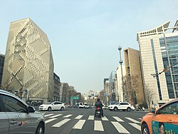
 Teheran-ro and Yeongdong-daero streets seen from Park Hyatt Seoul. | |
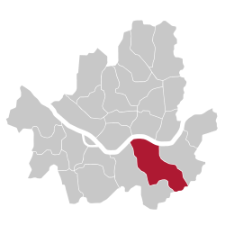
 Location of Gangnam District in Seoul | |
| Coordinates: 37°29′48″N 127°01′39″E / 37.49667°N 127.02750°E | |
| Country | |
| Region | Sudogwon |
| Special City | Seoul |
| Administrative dong | 26 |
| Government | |
| • Body | Gangnam-gu Council |
| • Mayor | Cho Seong-myeong (People Power) |
| • MNAs | List of MNAs |
| Area | |
| • Total | 39.49 km2 (15.25 sq mi) |
| Population (November, 2020)[1] | |
| • Total | 508,135 |
| • Density | 13,000/km2 (33,000/sq mi) |
| Time zone | UTC+9 (Korea Standard Time) |
| Postal code. | 06000 – 06499 |
| Area code(s) | +82-2-2226,400,500 |
| Website | gangnam.go.kr |
 | |


Gangnam District (Korean: 강남구; RR: Gangnam-gu; IPA: [ka̠ŋna̠m.gu]) is one of the 25 districts of Seoul, South Korea. The term Gangnam translates to "South of the [Han] River". Gangnam District is the third largest district in Seoul, with an area of 39.5 km2 (15.3 sq mi). As of the 2024 census, Gangnam District had a population of 556,570.[1] There is a high concentration of wealth in the district, with prices for an apartment as of 2024 more than double those in the rest of Seoul. Gangnam District is part of Gangnam School District Eight, along with the Seocho District. This district shares half of Gangnam-daero Gangnam Station area with Seocho District, which is one of the most crowded places in South Korea.[2]
However, it is home to Bongeunsa Temple, which dates back to the Unified Silla period, as well as Seonjeongneung, royal tombs of the Joseon Dynasty, and the gravesite of Gwangpyeong Daegun and his family’s land, which are preserved as national treasures. Apgujeong, in particular, became notable from the early Joseon period as it was the site where Han Myeong-hoe, a high-ranking official during King Sejo's reign, built and lived in his villa.
- ^ a b https://www.citypopulation.de/php/southkorea-admin.php?adm2id=11230%7C Gangnam-gu (City District, Seoul, South Korea) - Population Statistics ... - Retrieved 23-03-01
- ^ "Gangnam apartment prices jump 84 times in 40 years". 29 March 2020.
