Gap, Pennsylvania | |
|---|---|
 Store in Gap | |
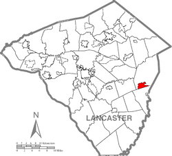
 Location in Lancaster County | |
| Coordinates: 39°59′14″N 76°01′14″W / 39.98722°N 76.02056°W | |
| Country | United States |
| State | Pennsylvania |
| County | Lancaster |
| Townships | Salisbury, Sadsbury |
| Area | |
| • Total | 2.91 sq mi (7.52 km2) |
| • Land | 2.90 sq mi (7.52 km2) |
| • Water | 0.00 sq mi (0.01 km2) |
| Elevation | 545 ft (166 m) |
| Population | |
| • Total | 2,186 |
| • Density | 753.27/sq mi (290.88/km2) |
| Time zone | UTC-5 (Eastern (EST)) |
| • Summer (DST) | UTC-4 (EDT) |
| ZIP code | 17527 |
| Area code | 717 |
| GNIS feature ID | 1175420[3] |
| FIPS code | 42-28376 |
Gap is a census-designated place (CDP) and unincorporated community in Salisbury Township, Lancaster County, Pennsylvania, United States, with a ZIP code of 17527. The population was 1,931 at the 2010 census.[4] U.S. Route 30 passes through the town, which is also the terminus for four Pennsylvania highways: 772, 741, 897, and the heavily used 41, which leads toward Wilmington, Delaware.
Gap lies approximately 16 miles (26 km) east of Lancaster and 49 miles (79 km) west of Philadelphia.
- ^ "ArcGIS REST Services Directory". United States Census Bureau. Retrieved October 12, 2022.
- ^ "Census Population API". United States Census Bureau. Retrieved October 12, 2022.
- ^ "Gap". Geographic Names Information System. United States Geological Survey, United States Department of the Interior.
- ^ "Total Population: 2010 Census DEC Summary File 1 (P1), Gap CDP, Pennsylvania". data.census.gov. U.S. Census Bureau. Retrieved September 22, 2020.

