Gary Junction Road –Western Australia | |
|---|---|
 | |
| Looking east along Gary Junction Road towards Mt Liebig | |
| General information | |
| Type | Track |
| Length | 852 km (529 mi) |
| Built by | Len Beadell |
| Major junctions | |
| ESE end | Tanami Road |
| WNW end | Gary Junction |
| Restrictions | |
| Permits | 3 |
| Fuel supply | |
| Facilities | Bore water, Jupiter well |
| ---- | |
The Gary Junction Road is an outback unsealed road in Australia built by Len Beadell in the 1960s as part of a network of roads for the Weapons Research Establishment at Woomera, South Australia. In its original form, the Gary Junction Road ran from Liebig bore in the Northern Territory to Callawa Station in Western Australia. On present day maps, it is depicted as running from the Tanami Road (Narwietooma turnoff) to Gary Junction, just east of the Canning Stock Route, a distance of 852 kilometres.[1] The road was named after Beadell's only son Gary.
-
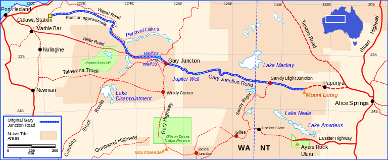 Map of the original Gary Junction Road 1350 km in length.

- ^ Hema, Maps (2005). Australia’s Great Desert Tracks NW Sheet (Map). Eight Mile Plains Queensland: Hema Maps. ISBN 978-1-86500-159-3.