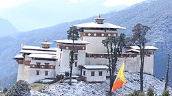
Gasa | |
|---|---|
 The view of highlander | |
| Coordinates: 27°55′N 89°41′E / 27.917°N 89.683°E | |
| Country | |
| District | Gasa District |
| Government The Government at the centre is supported by local governments in all the 20 districts / dzongkhags | |
| • Type | Local Government / Dzongkhag Tshogdu |
| • Chairperson / Thrizin | Kinley |
| • Governor / Dzongda | Sonam Jigme |
| • Member of Parliament (National Council) | Sangay Khandu |
| • Member of Parliament (National Assembly) | Damcho Dorji |
| • Member of Parliament (National Assembly) | Kinley Dorji |
| Population (2005) | |
| • Total | 3,116 |
| Time zone | UTC+6 (BTT) |
| Website | www.gasadzongkhag.gov.bt, www.nab.gov.bt, www.nationalcouncil.bt |
Gasa is a town near Gasa Dzong in Gasa District in northwestern Bhutan.[1]
At the 2005 census, its population was 3,116.[2] One of the twenty Dzongkhags [districts] of Bhutan, Gasa is an important northern Dzongkhag bordering Tibet. the place was visited and blessed by Ugyen Guru Rinpoche in the past, the close disciples of Tsangpa Gyare from the thirteenth century, the Indian Pandita Nagi Rinchen, and the numerous saints of the different schools of Buddhism from Tibet. It is also the place where Jamyang Lordo Senge, the eight in line of the Senge Lineage, who was the Lord of the golden throne of Ralung in Tibet, was born. in the main route between Bhutan and Tibet and, also it was wars between the two countries. unfortunately, they bring wars. The wining from the third legion of the Tibetan and Mongolian Army in 1656-1657 during the time of Tenzin Drukdra the second Desi. In Gasa they are many names of Gasa valley. The name which was later used for Gasa Dzong. it is the dwelling place of Damchen Gomo chargerlchen, the protector of Drubthop Trekhungpa,[3] a siddha, visited the land of medicinal herbs Bhutan around the thirteenth century. It is the home to layaps, a nomadic tribe which earns revenue by selling products made from yaks. Gasa is the famous for its hot springs, dzong snowman trek and royal highlander festival.
- ^ "NGA GeoName Database". National Geospatial-Intelligence Agency. Archived from the original on 2008-06-08. Retrieved 2008-07-03.
- ^ "Fact sheet: Population and Housing Census of Bhutan 2005" (PDF). Archived from the original (PDF) on 2011-07-06. Retrieved 2011-05-18.
- ^ Bstan-vdzin-rnam-rgyal, ed. (2008). Dzongs of Bhutan: fortresses of the Dragon kingdom (2. ed.). Thimphu: Bhutan Times. ISBN 978-99936-705-2-0.
