| Gauja National Park | |
|---|---|
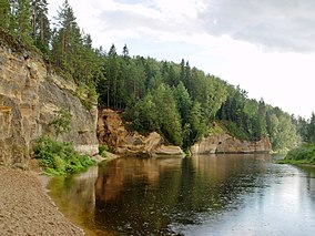
 Eagles' Cliffs on the Gauja | |
| Location | Latvia |
| Nearest city | Cēsis |
| Coordinates | 57°25′0″N 25°25′0″E / 57.41667°N 25.41667°E |
| Area | 917.87 km2 (354.39 sq mi)[1] |
| Established | 1973 |
| Governing body | Ministry of Environmental Protection and Regional Development |
| Website | Gauja National Park |
 | |
Gauja National Park (Latvian: Gaujas nacionālais parks) in Vidzeme is the largest national park in Latvia, with an area of 917.86 km2 running from north-east of Sigulda to south-west of Cēsis along the valley of the Gauja River, from which the park takes its name.[2]
It was established in order to protect slightly disturbed natural areas, promote nature tourism and ensure sustainable development in the area. The national park is characterized by a high biological diversity, rock outcrops and varied terrain shapes, springs, picturesque landscapes and many historical and cultural monuments from different centuries. The major part of the national park and the dominant is the old valley of the Gauja River. The valley is protected and at the same time it can be used for nature and cultural history tourism, as well as healthy recreation.
The park administration is based in Sigulda.
- ^ Gaujas Nacionālais Parks Protected Planet
- ^ Gauja National Park
