Gebenstorf | |
|---|---|
 | |
 Flag  Coat of arms | |
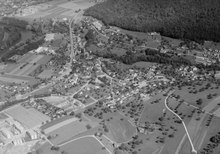
Location of Gebenstorf  | |
 Gebenstorf  Gebenstorf | |
| Coordinates: 47°29′N 8°14′E / 47.483°N 8.233°E | |
| Country | Switzerland |
| Canton | Aargau |
| District | Baden |
| Area | |
| • Total | 5.64 km2 (2.18 sq mi) |
| Elevation | 375 m (1,230 ft) |
| Highest elevation (Chörnlisberg) | 561 m (1,841 ft) |
| Lowest elevation | 330 m (1,080 ft) |
| Population (31 December 2018)[2] | |
| • Total | 5,414 |
| • Density | 960/km2 (2,500/sq mi) |
| Time zone | UTC+01:00 (Central European Time) |
| • Summer (DST) | UTC+02:00 (Central European Summer Time) |
| Postal code(s) | 5412 |
| SFOS number | 4029 |
| ISO 3166 code | CH-AG |
| Localities | Vogelsang |
| Surrounded by | Baden, Birmenstorf, Brugg, Turgi, Untersiggenthal, Windisch |
| Website | gebenstorf SFSO statistics |
Gebenstorf is a municipality in the district of Baden in the canton of Aargau in Switzerland.
- ^ a b "Arealstatistik Standard - Gemeinden nach 4 Hauptbereichen". Federal Statistical Office. Retrieved 13 January 2019.
- ^ "Ständige Wohnbevölkerung nach Staatsangehörigkeitskategorie Geschlecht und Gemeinde; Provisorische Jahresergebnisse; 2018". Federal Statistical Office. 9 April 2019. Retrieved 11 April 2019.