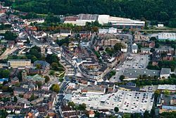
Geilenkirchen | |
|---|---|
 Aerial view | |
Location of Geilenkirchen within Heinsberg district  | |
| Coordinates: 50°57′55″N 6°07′10″E / 50.96528°N 6.11944°E | |
| Country | Germany |
| State | North Rhine-Westphalia |
| Admin. region | Köln |
| District | Heinsberg |
| Subdivisions | 13 |
| Government | |
| • Mayor (2020–25) | Daniela Ritzerfeld[1] (Ind.) |
| Area | |
• Total | 83 km2 (32 sq mi) |
| Elevation | 95 m (312 ft) |
| Population (2023-12-31)[2] | |
• Total | 28,399 |
| • Density | 340/km2 (890/sq mi) |
| Time zone | UTC+01:00 (CET) |
| • Summer (DST) | UTC+02:00 (CEST) |
| Postal codes | 52511 |
| Dialling codes | 02451; 02453; 02462 |
| Vehicle registration | HS, ERK, GK |
| Website | www.geilenkirchen.de |
Geilenkirchen (German pronunciation: [ˈɡaɪlənkɪʁçn̩] , Ripuarian: Jellekerke [ˈjæləˌkæʀ˦(ə)kə]) is a town in the district Heinsberg, in North Rhine-Westphalia, Germany. It is situated near the border with the Netherlands, on the river Wurm, approx. 15 km (9.3 mi) north-east of Heerlen and 20 km (12.4 mi) north of Aachen.
It was the site of Operation Clipper in November 1944.
The town gives its name to nearby NATO Air Base Geilenkirchen. The base is home to seventeen E-3A airborne early warning and control aircraft flown by aircrew from over fourteen nations.
On 24 July 2019 the highest temperature ever recorded in Germany was measured in Geilenkirchen at 40.5 °C (104.9 °F) during a heat wave that affected much of Europe.[3] The record was broken the following day when temperature in Lingen reached 42.6 °C (108.7 °F).[4]
- ^ Wahlergebnisse in NRW Kommunalwahlen 2020, Land Nordrhein-Westfalen, accessed 21 June 2021.
- ^ "Bevölkerung der Gemeinden Nordrhein-Westfalens am 31. Dezember 2023 – Fortschreibung des Bevölkerungsstandes auf Basis des Zensus vom 9. Mai 2011" (in German). Landesbetrieb Information und Technik NRW. Retrieved 2024-06-20.
- ^ Waidner, Jannik. "In Geilenkirchen in NRW: 40,5 Grad – Neuer Hitzerekord in Deutschland". Faz.net – via www.faz.net.
- ^ "Neuer Hitzerekord: 42,6 °C in Lingen (Emsland)!". www.nwzonline.de.


