 | |
| Continent | Asia |
|---|---|
| Region | Middle East |
| Coordinates | 29°30′N 47°45′E / 29.500°N 47.750°E |
| Area | Ranked 152nd |
| • Total | 17,820 km2 (6,880 sq mi) |
| • Land | 100% |
| • Water | 0% |
| Coastline | 499 km (310 mi) |
| Highest point | Mutla Ridge 306 m (1,004 ft) |
| Lowest point | Persian Gulf 0 m (0 ft) |
| Longest river | No permanent rivers |
| Largest lake | None |
| Climate | Arid climate |
| Natural resources | Petroleum, fish, shrimp, natural gas |
| Natural hazards | Dust storms, sand storms, flash floods, thunderstorms |
| Environmental issues | Air pollution, water pollution, desertification, limited natural fresh water |
| Exclusive economic zone | 11,026 km2 (4,257 sq mi) |
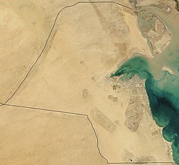
Kuwait is a country in West Asia, bordering the Persian Gulf, between Iraq and Saudi Arabia. Kuwait is located at the far northwestern corner of the Persian Gulf. Kuwait is 17,820 square kilometres in size. At its most distant points, it is about 200 km (120 mi) north to south, and 170 km (110 mi) east to west. Kuwait has 10 islands. Kuwait's area consists mostly of desert.