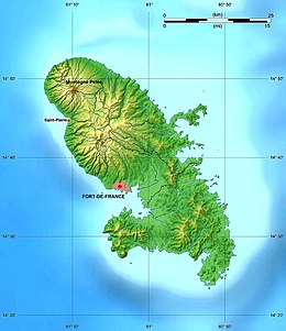
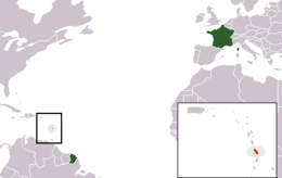
The French Overseas Department of Martinique is a Caribbean island belonging to the Lesser Antilles group in the Caribbean Sea, southeast of Cuba and north of Trinidad and Tobago. It is part of the French West Indies. It lies near the Tropic of Cancer between 14° 26' and 14°53' latitude north and 63° 9' and 63° 34' longitude west. At most some 50 miles long and 22 miles wide, Martinique covers an area of 425 square miles. Its coastline is so indented that no part of the island is more than seven miles from the sea. 14°40′N 61°00′W / 14.667°N 61.000°W
Nickname: Island of Flowers | |
|---|---|
 Map of Martinique | |
 | |
| Geography | |
| Location | Caribbean Sea |
| Coordinates | 14°40′N 61°00′W / 14.667°N 61.000°W |
| Archipelago | Windward Islands |
| Area | 1,060 km2 (410 sq mi) |
| Coastline | 350 km (217 mi) |
| Highest elevation | 1,397 m (4583 ft) |
| Highest point | Montagne Pelée |
| Administration | |
France | |
| Overseas department | Martinique |
| Largest settlement | Fort-de-France (pop. 81,006) |
| Demographics | |
| Population | 372,594 (2020) |
| Pop. density | 405.2/km2 (1049.5/sq mi) |
| Ethnic groups | African and African-white-Indian mixture 90%, white 5%, Indian Tamil or East Indian, Chinese less than 5% |
The "Island of flowers ", as Martinique is called, is a volcanic island with rather low mountains which form steep cliffs along the coasts. It can be divided into three natural zones: a mountainous region in the north, with its two highest points at Mount Pelée (an active volcano, 4,428 ft.) and the Pitons du Carbet (3,960 ft.); the Lamentin Plain in the center; and a hilly region in the south, composed of eroded remnants of old volcanoes and dominated by the Montagne du Vauclin (1,656 ft.) and the Morne du Diamant (1,567 ft.).