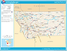
Montana is one of the eight Mountain States, located in the north of the region known as the Western United States. It borders North Dakota and South Dakota to the east. Wyoming is to the south, Idaho is to the west and southwest, and the Canadian provinces of British Columbia, Alberta, and Saskatchewan are to the north, making it the only state to border three Canadian provinces.
With an area of 147,040 square miles (380,800 km2),[1] Montana is slightly larger than Japan. It is the fourth-largest state in the United States after Alaska, Texas, and California,[2] and the largest landlocked state.[3]
- ^ "United States Summary: 2010, Population and Housing Unit Counts, 2010 Census of Population and Housing" (PDF) (PDF). United States Census Bureau. September 2012. p. 41 (Table 18). Retrieved April 11, 2014.
- ^ Anderson 2012, p. 4.
- ^ "Montana | Capital, Population, Climate, Map, & Facts". Encyclopedia Britannica. Retrieved February 17, 2021.