 | |
| Continent | Europe |
|---|---|
| Region | Southern Europe North Africa Iberian Peninsula Macaronesia |
| Coordinates | 39°22′13.65″N 8°8′25.13″W / 39.3704583°N 8.1403139°W |
| Area | Ranked 109th |
| • Total | 92,391 km2 (35,672 sq mi) |
| • Land | 99.55% |
| • Water | .45% |
| Coastline | 1,794 km (1,115 mi) |
| Borders | Total land borders: Portugal-Spain border (1214 km) |
| Highest point | Mount Pico (Azores) 2,351 m (7,713 ft) Torre (Iberian Peninsula) 1,993 m (6,539 ft) |
| Lowest point | Sea level (Atlantic Ocean) |
| Longest river | Tagus (275 km within Portugal) |
| Largest lake | Lake Alqueva |
| Exclusive economic zone | 1,727,408 km2 (666,956 sq mi) |
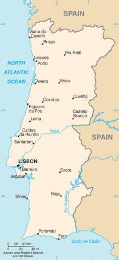
Portugal is a coastal nation in western Europe, located at the western end of the Iberian Peninsula, bordering Spain (on its northern and eastern frontiers: a total of 1,215 kilometres (755 mi)). The Portuguese territory also includes a series of archipelagos in the Atlantic Ocean (the Azores and Madeira), which are strategic islands along the North Atlantic. The extreme south is not too far from the Strait of Gibraltar, leading to the Mediterranean Sea. In total, the country occupies an area of 92,090 square kilometres (35,560 sq mi) of which 91,470 square kilometres (35,320 sq mi) is land and 620 square kilometres (240 sq mi) water.[1]
Despite these definitions, the Portugal-Spain border remains an unresolved territorial dispute between the two countries. Portugal does not recognise the border between Caia and Ribeira de Cuncos River deltas, since the beginning of the 1801 occupation of Olivenza by Spain. This territory, though under de facto Spanish occupation, remains a de jure part of Portugal, consequently no border is henceforth recognised in this area.[2]
- ^ "Portugal". CIA - The World Factbook. Retrieved 2009-11-28.
- ^ "A questão de Olivença". olivenca.org. Archived from the original on 3 February 2021. Retrieved 29 January 2021.