 | |
| Continent | Africa[1] |
|---|---|
| Region | East Africa |
| Coordinates | 2°00′S 30°0′E / 2.000°S 30.000°E |
| Area | Ranked 144th |
| • Total | 26,338 km2 (10,169 sq mi) |
| • Land | 97% |
| • Water | 3% |
| Coastline | 0 km (0 mi) |
| Borders | 893 km (DRC 217 km, Burundi 290 km, Tanzania 217 km, Uganda 169 km) |
| Highest point | Mount Karisimbi 4507 m |
| Lowest point | Rusizi River 950 m |
| Longest river | Nyabarongo |
| Largest lake | Lake Kivu
 |
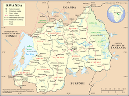
Rwanda is located in East Africa, to the east of the Democratic Republic of the Congo, at the co-ordinates 2°00′S 30°0′E / 2.000°S 30.000°E.
At 26,338 square kilometres (10,169 sq mi), Rwanda is the world's 149th-largest country.[2] It is comparable in size to Haiti or the state of Massachusetts in the United States.[3][4] The entire country is at a high altitude: the lowest point is the Rusizi River at 950 metres (3,117 ft) above sea level.[3]
Rwanda is located in Central/Eastern Africa, and is bordered by the Democratic Republic of the Congo to the west, Uganda to the north, Tanzania to the east, and Burundi to the south.[3] It lies a few degrees south of the equator and is landlocked.[5] The capital, Kigali, is located near the centre of Rwanda.[6]
- ^ CIA World Factbook
- ^ Central Intelligence Agency (CIA). "Rank Order – Area". The World Factbook. Archived from the original on June 13, 2007. Retrieved 2012-02-16.
- ^ a b c Central Intelligence Agency (CIA) (2012). "Rwanda". The World Factbook. Retrieved 2012-04-02.
- ^ Richards, Charles (1994-07-24). "Rwanda: Question Time: How could it happen?: Rebellion, slaughter, exodus, cholera: the catastrophe in Rwanda is beyond our worst imaginings. Who is to blame? Who are the Hutus and Tutsis? Can peace ever be restored? Some answers ..." The Independent. London. Retrieved 2012-02-16.
- ^ Department of State (2012). "Background Note: Rwanda". Background Notes. Retrieved 2012-02-16.
- ^ Encyclopædia Britannica (2010). "Rwanda". Retrieved 2012-02-16.