 | |
| Continent | Africa |
|---|---|
| Region | Indian Ocean |
| Coordinates | 4°35′S 55°40′E / 4.583°S 55.667°E |
| Area | Ranked 180th |
| • Total | 452 km2 (175 sq mi) |
| • Land | 100% |
| • Water | 0% |
| Coastline | 491 km (305 mi) |
| Borders | None |
| Highest point | Morne Seychellois 905 metres (2,969 ft) |
| Lowest point | Indian Ocean 0 m |
| Exclusive economic zone | 1,336,559 km2 (516,048 sq mi) |
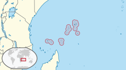
Seychelles is a small island country east of the African continent located in the Sea of Zanj due north of Madagascar, with Antsiranana as its nearest foreign city.[1] Seychelles lies between approximately 4ºS and 10ºS and 46ºE and 54ºE. The nation is an archipelago of 155 tropical islands, some granite and some coral, the majority of which are small and uninhabited. The landmass is only 452 km2 (175 sq mi), but the islands are spread wide over an exclusive economic zone of 1,336,559 km2 (516,048 sq mi). About 90 percent of the population of 100,000 live on Mahé, 9 percent on Praslin and La Digue. Around a third of the land area is the island of Mahé and a further third the atoll of Aldabra.[2]
There are two distinct regions, the granitic islands, the world's only oceanic islands of granitic rock and the coralline outer islands. The granite islands are the world's oldest ocean islands, while the outer islands are mainly very young, though the Aldabra group and St Pierre (Farquhar Group) are unusual, raised coral islands that have emerged and submerged several times during their long history, the most recent submergence dating from about 125,000 years ago[3]
- ^ Werema, Gilbert. "Safeguarding Tourism and Tuna: Seychelles’ Fight against the Somali Piracy Problem." (2012).
- ^ "Geography of Seychelles - Archive - Seychelles Nation". www.nation.sc. Retrieved 2020-05-26.
- ^ "Geography of Seychelles | Mauritius, Seychelles, Reunion: Holidays & Travel". Retrieved 2020-05-26.