This article may require cleanup to meet Wikipedia's quality standards. The specific problem is: Condense sections and remove areas with no information. (April 2013) |
 | |
| Continent | South America |
|---|---|
| Region | Caribbean |
| Coordinates | 4°00′N 56°00′W / 4.000°N 56.000°W |
| Area | Ranked 90th |
| • Total | 163,820 km2 (63,250 sq mi) |
| • Land | 95.33% |
| • Water | 4.67% |
| Coastline | 386 km (240 mi) |
| Borders | total length 1,707 km (1,061 mi) |
| Highest point | Juliana Top 1,230 meters (4,040 ft) |
| Lowest point | Caribbean Sea 0 metres (0 ft) |
| Longest river | Courantyne River 724 km (450 mi) |
| Largest lake | Brokopondo Reservoir 1,560 km (970 mi) |
| Exclusive economic zone | 127,772 km2 (49,333 sq mi) |

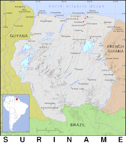
Suriname is located in the northern part of South America and is part of Caribbean South America, bordering the North Atlantic Ocean, between French Guiana and Guyana. It is mostly covered by tropical rainforest, containing a great diversity of flora and fauna that, for the most part, are increasingly threatened by new development. There is a relatively small population, most of which live along the coast.
There are currently two unresolved border disputes that affect the geography of Suriname, namely the Tigri Area in the southwestern region near Guyana and also the Marouini/Litani region with French Guiana in the southeast.