 | |
| Continent | Asia |
|---|---|
| Region | |
| Area | |
| • Total | 53,483 km2 (20,650 sq mi) |
| Coastline | 0 km (0 mi) |
| Borders | |
| Highest point | Nanda Devi 7,816 metres (25,643 ft) |
| Lowest point | Sharda Sagar Reservoir 187 metres (614 ft) |
| Longest river | Ganges |
| Largest lake | Ramganga–Sonanadi Reservoir |
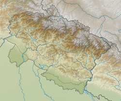
Uttarakhand has a total geographic area of 53,483 km2, of which 86% is mountainous and 65% is covered by forest.[1] Most of the northern parts of the state are part of Greater Himalaya ranges, covered by the high Himalayan peaks and glaciers, while the lower foothills were densely forested till denuded by the British log merchants and later, after independence, by forest contractors. Recent efforts in reforestation, however, have been successful in restoring the situation to some extent. The unique Himalayan ecosystem plays host to many animals (including bharal, snow leopards, leopards and tigers), plants and rare herbs. Two of India's great rivers, the Ganges and the Yamuna take birth in the glaciers of Uttarakhand, and are fed by myriad lakes, glacial melts and streams.[2]
- ^ "State of Uttarakhand" (PDF). Archived from the original (PDF) on 23 May 2012.
- ^ Himalayan Rivers, Lakes and Glaciers. New Delhi: Indus Pub. Co.
