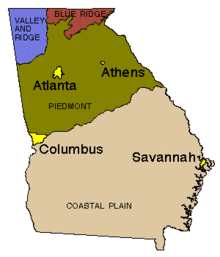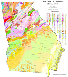


The U.S. state of Georgia is commonly divided into four geologic regions that influence the location of the state's four traditional physiographic regions.[1][2] The four geologic regions include the Appalachian foreland, Blue Ridge, Piedmont, and Coastal Plain. These four geologic regions commonly share names with and typically overlap the four physiographic (i.e. topographic) regions of the state: the Appalachian Plateau and adjacent Valley and Ridge; the Blue Ridge; the Piedmont and the Coastal Plain.
The geologic regions of the state, established by geologists based on relationships between stratigraphic units, significantly influence the physiographic regional names used by physical geographers. Geologic regions of the state, however, do not perfectly coincide with physiographic regions of the state. Most geologic regions (terranes) in the state are separated from one another by major thrust faults that formed during the growth of the Appalachian Mountains. The Appalachian foreland, for example, is separated from the geologic Blue Ridge by the Talladega-Cartersville-Great Smoky fault. The geologic Blue Ridge is separated from the geologic Piedmont by the Brevard fault zone. The Fall Line, the surface expression of the Coastal Plain unconformity, is the geologic boundary between the Piedmont and the Coastal Plain.
- ^ U.S. Geological Survey. "Georgia geological map data". U.S. Geological Survey, Online Spatial Data, Geology, by state. Retrieved July 13, 2023.
- ^ Usery, Lynn (July 1, 2003). "Geographic Regions of Georgia". New Georgia Encyclopedia. Retrieved July 13, 2023.