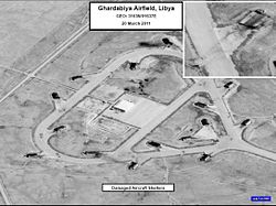
Ghardabiya Airbase Sirte Airport | |||||||||||||||
|---|---|---|---|---|---|---|---|---|---|---|---|---|---|---|---|
 United States Department of Defense reconnaissance photo of hangars at Ghardabiya | |||||||||||||||
| Summary | |||||||||||||||
| Airport type | Military/Public | ||||||||||||||
| Serves | Sirte, Libya | ||||||||||||||
| Elevation AMSL | 270 ft / 82 m | ||||||||||||||
| Coordinates | 31°03′38″N 16°36′42″E / 31.06056°N 16.61167°E | ||||||||||||||
| Map | |||||||||||||||
 | |||||||||||||||
| Runways | |||||||||||||||
| |||||||||||||||
Ghardabiya Airbase (IATA: SRX, ICAO: HLGD) is a dual-function airbase for the Libyan Air Force 15 kilometres (9.3 mi) south of the Mediterranean coastal city of Sirte.[4] It also incorporates an airport for civilian use.[5]
All runways have 305 metres (1,001 ft) displaced thresholds.
The Sirte non-directional beacon (Ident: SRT) is located 7.8 nautical miles (14.4 km) north of the airport, in the city. The Sirte VOR-DME (Ident: SRT) is located on the field.[6][7]
- ^ Airport information for Ghardabiya Airbase at Great Circle Mapper.
- ^ "Sirte/Ghardabya International". SkyVector. Retrieved 17 September 2018.
- ^ "Gardabya Airport". Google Maps. Retrieved 17 September 2018.
- ^ "Archived copy" (PDF). Archived from the original (PDF) on 2011-05-30. Retrieved 2011-03-23.
{{cite web}}: CS1 maint: archived copy as title (link) - ^ Dagher, Sam; Trofimov, Yaroslav; Hodge, Nathan (2011-03-21). "Allies Press Libya Attacks". Wall Street Journal. ISSN 0099-9660. Retrieved 2018-08-21.
- ^ "Sirte NDB". Our Airports. Retrieved 17 September 2018.
- ^ "Sirte VOR". Our Airports. Retrieved 17 September 2018.
