| Gibraltar Dam | |
|---|---|
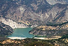
 Bird's eye view of the dam and lower part of the reservoir | |
| Country | United States |
| Location | Santa Barbara County, California |
| Coordinates | 34°31′37″N 119°41′13″W / 34.52694°N 119.68694°W[1] |
| Construction began | 1913[2] |
| Opening date | January 23, 1920[3] |
| Construction cost | $2 million (1920 dollars)[3] |
| Owner(s) | City of Santa Barbara |
| Dam and spillways | |
| Type of dam | Concrete arch |
| Impounds | Santa Ynez River |
| Height | 194.5 ft (59.3 m)[4] |
| Length | 600 ft (180 m)[4] |
| Reservoir | |
| Creates | Gibraltar Reservoir |
| Total capacity | Original: 15,374 acre⋅ft (18,964,000 m3)[5] Most recent survey (2017): 4,968 acre⋅ft (6,128,000 m3)[5] Current (Estimate February 2019): 4,314 acre⋅ft (5,321,000 m3)[6] |
| Catchment area | 216 sq mi (560 km2)[4] |
| Surface area | 248 acres (100 ha)[4] |
| Normal elevation | 1,400 ft (430 m) max[7] |
| Power Station | |
| Installed capacity | 820 KW[8] |
| Annual generation | 1,874,000 KWh[8] |
Gibraltar Dam is located on the Santa Ynez River, in southeastern Santa Barbara County, California, in the United States. Forming Gibraltar Reservoir, the dam is owned by the city of Santa Barbara. Originally constructed in 1920 and expanded in 1948, the dam and reservoir are located in a remote part of the Los Padres National Forest.
The main purpose of Gibraltar Dam is domestic water supply. It provides about 4,600 acre-feet (5,700,000 m3) of water to Santa Barbara each year, supplying almost 30% of the city's needs.[7] Water diverted from the dam also powers a small hydroelectric plant. Due to having lost a massive portion of its capacity to sediment build-up, the lake can often fill and spill after a single storm,[9] while drying up completely in some years.[10] As of February 2019, sedimentation has reduced the reservoir's capacity to 4,314 acre-feet (5,321,000 m3), only 19% of its designed capacity.[11]
The dam is built in a part of the Santa Ynez River called the "Gibraltar Narrows" that gave its name to the Gibraltar (or Sunbird) mercury mine, which operated next to what is now Gibraltar Reservoir between the 1870s and 1990s.[12]
- ^ "Gibraltar Dam". Geographic Names Information System. United States Geological Survey, United States Department of the Interior. 1981-01-19. Retrieved 2018-01-13.
- ^ Cite error: The named reference
ENR 1920was invoked but never defined (see the help page). - ^ a b Cite error: The named reference
Municipal Journalwas invoked but never defined (see the help page). - ^ a b c d "Gibraltar Dam". National Dam Performance Program. Stanford University. Archived from the original on 2012-12-11. Retrieved 2012-09-18.
- ^ a b Cite error: The named reference
USBRwas invoked but never defined (see the help page). - ^ "Rainfall and Reservoir Summary" (PDF). Santa Barbara County - Flood Control District. February 17, 2019. Archived from the original (PDF) on February 26, 2019. Retrieved February 17, 2019.
- ^ a b Cite error: The named reference
cosb gibraltarwas invoked but never defined (see the help page). - ^ a b "City of Santa Barbara, California; Notice of Preliminary Determination of a Qualifying Conduit Hydropower Facility and Soliciting Comments and Motions To Intervene". Federal Register. 78 (196). 2013-10-09. Retrieved 2018-01-18.
- ^ Cite error: The named reference
2014 Hydrology Reportwas invoked but never defined (see the help page). - ^ Palminteri, John (2013-11-08). "Water Worry: Gibraltar Dam Empty and Cachuma Lake Now Down to 44 Percent". KEYT. Archived from the original on 2018-11-23. Retrieved 2018-01-14.
- ^ "Rainfall and Reservoir Summary" (PDF). Santa Barbara County - Flood Control District. February 17, 2019. Archived from the original (PDF) on February 26, 2019. Retrieved February 17, 2019.
- ^ Blunden, Devon (2009-04-19). "Lost Secrets of the Sunbird Quicksilver Mine". Santa Barbara Independent. Retrieved 2017-11-14.