| Gilgandra Shire New South Wales | |||||||||||||||
|---|---|---|---|---|---|---|---|---|---|---|---|---|---|---|---|
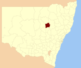
 Location in New South Wales | |||||||||||||||
| Coordinates | 31°42′S 148°41′E / 31.700°S 148.683°E | ||||||||||||||
| Population |
| ||||||||||||||
| • Density | 0.87593/km2 (2.2686/sq mi) | ||||||||||||||
| Established | 1906 | ||||||||||||||
| Area | 4,836 km2 (1,867.2 sq mi) | ||||||||||||||
| Mayor | Doug Batten (Independent) | ||||||||||||||
| Council seat | Gilgandra | ||||||||||||||
| Region | Orana | ||||||||||||||
| State electorate(s) | Barwon | ||||||||||||||
| Federal division(s) | Parkes | ||||||||||||||
 | |||||||||||||||
| Website | Gilgandra Shire | ||||||||||||||
| |||||||||||||||
Gilgandra Shire is a local government area in the Orana region of New South Wales, Australia. The Shire is located adjacent to the junction of the Newell, Oxley and Castlereagh highways and can be reached in about six hours by car from Sydney CBD. The Shire lies on the Castlereagh River and includes part of the Warrumbungles National Park. The shire was constituted in 1906.
The mayor of Gilgandra Shire Council is Cr. Doug Batten, an independent politician.
- ^ Australian Bureau of Statistics (27 June 2017). "Gilgandra (A)". 2016 Census QuickStats. Retrieved 7 July 2017.
- ^ "3218.0 – Regional Population Growth, Australia, 2017–18". Australian Bureau of Statistics. 27 March 2019. Archived from the original on 27 March 2019. Retrieved 27 March 2019. Estimated resident population (ERP) at 30 June 2018.