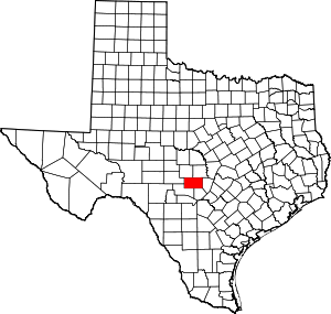
Gillespie County | |
|---|---|
 The Gillespie County Courthouse in Fredericksburg | |
 Location within the U.S. state of Texas | |
 Texas's location within the U.S. | |
| Coordinates: 30°19′N 98°57′W / 30.31°N 98.95°W | |
| Country | |
| State | |
| Founded | 1848 |
| Named for | Robert Addison Gillespie |
| Seat | Fredericksburg |
| Largest city | Fredericksburg |
| Area | |
• Total | 1,062 sq mi (2,750 km2) |
| • Land | 1,058 sq mi (2,740 km2) |
| • Water | 3.5 sq mi (9 km2) 0.3% |
| Population (2020) | |
• Total | 26,725 |
| • Density | 25/sq mi (9.7/km2) |
| Time zone | UTC−6 (Central) |
| • Summer (DST) | UTC−5 (CDT) |
| Congressional district | 21st |
| Website | www |
Gillespie County is a county located on the Edwards Plateau in the U.S. state of Texas. As of the 2020 census, its population was 26,725.[1] The county seat is Fredericksburg.[2] It is located in the heart of the rural Texas Hill Country in Central Texas. Gillespie is named for Robert Addison Gillespie, a soldier in the Mexican–American War. It is known as the birthplace of 36th president of the United States of America Lyndon B. Johnson.
On December 15, 1847, a petition was submitted to create Gillespie County. In 1848, the legislature formed Gillespie County from Bexar and Travis Counties. While the signers were overwhelmingly German immigrants, names also on the petition were Castillo, Pena, Munos, and a handful of non-German Anglo names.
Gillespie County comprises the Fredericksburg, TX Micropolitan Statistical Area.
- ^ "Gillespie County, Texas". United States Census Bureau. Retrieved February 23, 2021.
- ^ "Find a County". National Association of Counties. Archived from the original on May 31, 2011. Retrieved June 7, 2011.