| Lake Columbia | |
|---|---|
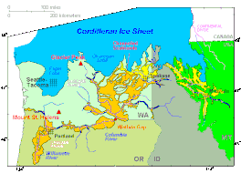
 Cordilleran Ice Sheet maximum extent of Glacial Lake Missoula (eastern) and Glacial Lake Columbia (western)
areas swept by Missoula and Columbia floods | |
| Location | North America |
| Coordinates | 47°57′N 118°58′W / 47.95°N 118.96°W |
| Lake type | former lake |
| Primary inflows | Corderillian Ice Sheet |
| Primary outflows | Foster Coulee Moses Coulee Grand Coulee |
| Basin countries | United States |
| Max. length | 30 mi (48 km) |
| Max. width | 20 mi (32 km) |
| Surface area | 500 sq mi (1,295 km2) |
| Max. depth | 600 ft (183 m) |
| Surface elevation | 1,600 ft (488 m) |

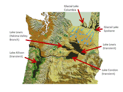
Glacial Lake Columbia was the lake formed on the ice-dammed Columbia River behind the Okanogan lobe of the Cordilleran Ice Sheet when the lobe covered 500 square miles (1,300 km2) of the Waterville Plateau west of Grand Coulee in central Washington state during the Wisconsin glaciation.[1] Lake Columbia was a substantially larger version of the modern-day lake behind the Grand Coulee Dam. Lake Columbia's overflow – the diverted Columbia River – drained first through Foster Coulee, and as the ice dam grew, then through Moses Coulee, and finally, the Grand Coulee.[2][3]
- ^ The Wisconsin glaciation began about 80,000 years ago and ended around 10,000 years ago.
- ^ "Description: Ice Sheets and Glaciations". USGS. Retrieved 14 November 2009.
- ^ Atwater, Brian F. (1984). "Periodic floods from glacial Lake Missoula into the Sanpoil arm of glacial Lake Columbia, northeastern Washington". Geology. 12 (8). The Geological Society of America: 464–467. Bibcode:1984Geo....12..464A. doi:10.1130/0091-7613(1984)12<464:PFFGLM>2.0.CO;2.

