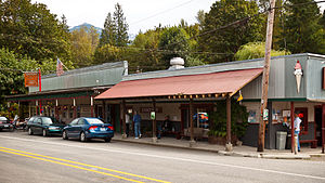
Glacier, Washington | |
|---|---|
 | |
 Location of Glacier, Washington | |
| Coordinates: 48°53′18″N 121°56′2″W / 48.88833°N 121.93389°W | |
| Country | United States |
| State | Washington |
| County | Whatcom |
| Area | |
| • Total | 3.0 sq mi (7.8 km2) |
| • Land | 3.0 sq mi (7.8 km2) |
| • Water | 0.0 sq mi (0.0 km2) |
| Elevation | 906 ft (276 m) |
| Population (2020) | |
| • Total | 300 |
| • Density | 100/sq mi (38/km2) |
| Time zone | UTC-8 (Pacific (PST)) |
| • Summer (DST) | UTC-7 (PDT) |
| ZIP code | 98244 |
| Area code | 360 |
| FIPS code | 53-26875[1] |
| GNIS feature ID | 1519971[2] |
Glacier is a census-designated place in the North Fork Nooksack River Valley, at an elevation of 906 ft., just 10 miles northwest of the Mount Baker Summit towering nearly 10,000 ft above it, in Whatcom County, Washington, United States. The population was 300 at the 2020 census.[3]
Glacier is the community closest to Mt. Baker, and a 20-mile drive from the Mt. Baker Ski Area. The Glacier Public Service Center, staffed by both United States Forest Service and National Park Service personnel, is less than a mile east.[4]
- ^ "U.S. Census website". United States Census Bureau. Retrieved January 31, 2008.
- ^ "US Board on Geographic Names". United States Geological Survey. October 25, 2007. Retrieved January 31, 2008.
- ^ "Census Bureau profile: Glacier, Washington". United States Census Bureau. May 2023. Retrieved May 9, 2024.
- ^ http://www.nps.gov/noca/planyourvisit/visitorcenters.htm National Park Service. Retrieved 2016-02-25.