Glorit | |
|---|---|
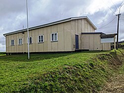
 Glorit community hall | |
 | |
| Coordinates: 36°27′53″S 174°26′45″E / 36.464716°S 174.445907°E | |
| Country | New Zealand |
| Region | Auckland Region |
| Ward | Rodney ward |
| Local board | Rodney Local Board |
| Subdivision | Kumeū subdivision |
| Electorates | |
| Government | |
| • Territorial Authority | Auckland Council |
Glorit is a rural community in the Auckland Region of New Zealand's North Island. State Highway 16 runs through the area, connecting to Tauhoa 12 km to the north and Helensville to the south.[1][2]
The settlement was established in 1868 and celebrated its 150th anniversary in 2018.[3]
Two marae are located south of the main settlement: Araparera Marae or Te Aroha Pā and its Kia Mahara meeting house, and Kakanui Marae and Te Kia Ora meeting house.[4] Both are tribal meeting grounds for Ngāti Rāngo, Ngāti Whātua and Ngāti Whātua o Kaipara.[5]
A falling transmission tower at Glorit caused a power outage on 20 June 2024 that affected almost 100,000 properties in Northland, which is most of the region.[6] The fallen tower is visible from SH16.
- ^ Peter Dowling, ed. (2004). Reed New Zealand Atlas. Reed Books. pp. map 11. ISBN 0-7900-0952-8.
- ^ Roger Smith, GeographX (2005). The Geographic Atlas of New Zealand. Robbie Burton. pp. map 31. ISBN 1-877333-20-4.
- ^ Dickey, Delwyn (2 March 2018). "Glorit residents celebrate 150 years". Stuff.co.nz. Rodney Times.
- ^ "Māori Maps". maorimaps.com. Te Potiki National Trust.
- ^ "Te Kāhui Māngai directory". tkm.govt.nz. Te Puni Kōkiri.
- ^ "Northland power outage: A fallen pylon put Glorit on the map". 5 July 2024.