Gmina Nowa Ruda
Nowa Ruda Commune | |
|---|---|
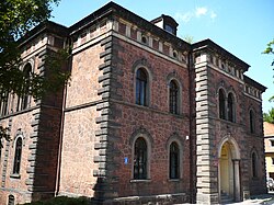
 Gmina office in Nowa Ruda | |
 | |
| Coordinates (Nowa Ruda): 50°35′N 16°30′E / 50.583°N 16.500°E | |
| Country | |
| Voivodeship | Lower Silesian |
| County | Kłodzko |
| Seat | Nowa Ruda |
| Sołectwos (Incorporated villages) | Bartnica, Bieganów, Bożków, Czerwieńczyce, Dworki, Dzikowiec, Jugów, Krajanów, Ludwikowice Kłodzkie, Nowa Wieś Kłodzka, Przygórze, Sokolec, Sokolica, Świerki, Włodowice, Wolibórz |
| Area | |
• Total | 139.66 km2 (53.92 sq mi) |
| Population (2019-06-30[1]) | |
• Total | 11,599 |
| • Density | 83/km2 (220/sq mi) |
| Time zone | UTC+1 (CET) |
| • Summer (DST) | UTC+2 (CEST) |
| Vehicle registration | DKL |
| Website | http://gmina.nowaruda.pl/ |
Gmina Nowa Ruda is a rural gmina (administrative district) in Kłodzko County, Lower Silesian Voivodeship, in south-western Poland. Its seat is the town of Nowa Ruda, although the town is not part of the territory of the gmina.
The gmina covers an area of 139.66 square kilometres (53.9 sq mi), and as of 2019 its total population is 11,599.
- ^ "Population. Size and structure and vital statistics in Poland by territorial division in 2019. As of 30th June". stat.gov.pl. Statistics Poland. 2019-10-15. Archived from the original on 2021-04-19. Retrieved 2020-02-14.

