Goessel, Kansas | |
|---|---|
 Alexanderwohl Mennonite Church 1 mile north of Goessel (2007) | |
 Location within Marion County and Kansas | |
 | |
| Coordinates: 38°14′49″N 97°20′44.67″W / 38.24694°N 97.3457417°W[1] | |
| Country | United States |
| State | Kansas |
| County | Marion |
| Township | West Branch |
| Platted | 1910 |
| Incorporated | 1952 |
| Named for | Kurt von Goessel |
| Government | |
| • Type | Mayor–Council |
| • Mayor | Dave Schrag[2] |
| Area | |
• Total | 0.38 sq mi (0.98 km2) |
| • Land | 0.38 sq mi (0.98 km2) |
| • Water | 0.00 sq mi (0.00 km2) |
| Elevation | 1,532 ft (467 m) |
| Population | |
• Total | 556 |
| • Density | 1,500/sq mi (570/km2) |
| Time zone | UTC-6 (CST) |
| • Summer (DST) | UTC-5 (CDT) |
| ZIP code | 67053 |
| Area code | 620 |
| FIPS code | 20-26750 |
| GNIS ID | 2394920[1] |
| Website | goesselks.com |
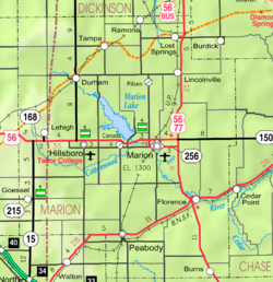
Goessel is a city in Marion County, Kansas, United States.[1] As of the 2020 census, the population of the city was 556.[4] The city was named after Captain Kurt von Goessel (1852–1895) who went down with his ship, the Elbe, in the English Channel after it was rammed. It is located about 11 miles north of North Newton on the west side of K-15 highway.
- ^ a b c d U.S. Geological Survey Geographic Names Information System: Goessel, Kansas
- ^ Cite error: The named reference
gov1was invoked but never defined (see the help page). - ^ "2019 U.S. Gazetteer Files". United States Census Bureau. Retrieved July 24, 2020.
- ^ a b "Profile of Goessel, Kansas in 2020". United States Census Bureau. Archived from the original on November 11, 2021. Retrieved November 11, 2021.