This article needs additional citations for verification. (June 2019) |
Gondia district | |
|---|---|
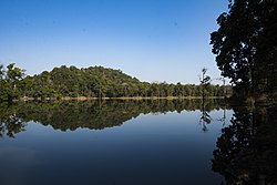
 Forest in Nagzira | |
 Location in Maharashtra | |
| Coordinates (Gondia): 21°27′41″N 80°11′29″E / 21.46139°N 80.19139°E | |
| Country | |
| State | Maharashtra |
| Division | Nagpur |
| Headquarters | Gondia |
| Tehsils | 1. Gondia, 2. Goregaon, 3. Tirora, 4. Arjuni Morgaon, 5. Deori, 6. Amgaon, 7. Salekasa, 8. Sadak Arjuni |
| Government | |
| • Body | Gondia Zilla Parishad |
| • Guardian Minister | Aditi Tatkare (Cabinet Minister) |
| • President Zilla Parishad | Pankaj Rahangdale |
| • District collector | Prajit Nair (IAS) |
| • CEO Zilla Parishad | Anil Patil (IAS) |
| • MPs | |
| Area | |
| • Total | 5,234 km2 (2,021 sq mi) |
| Population (2011) | |
| • Total | 1,322,507 |
| • Density | 250/km2 (650/sq mi) |
| • Urban | 11.95% |
| Demographics | |
| • Literacy | 85% |
| • Sex ratio | 999 |
| Time zone | UTC+05:30 (IST) |
| Major highways | NH 53, NH 543, NH 753, MSH 11, SH 249, SH 266, SH 275, SH 354, SH 366 |
| Average annual precipitation | 1197 mm |
| Website | gondia |
Gondia district (also known as Gondiya, Marathi pronunciation: [ɡon̪d̪iaː]) is an administrative district in the state of Maharashtra in India. The district headquarter is located at Gondia. The district occupies an area of 5,234 km2 (2,021 sq mi) and has a population of 1,322,507 of which 11.95% were urban (as of 2011[update]).[1] The district is part of Nagpur Division. There are 8 Talukas in Gondia District. Gondia Airport is second airport in Vidharbha region and serves the city of Gondia.
- ^ "Census GIS India". Archived from the original on 3 July 2007. Retrieved 4 October 2019.
