| Goobarragandra | |
|---|---|
 | |
 | |
| Location | |
| Country | Australia |
| State | New South Wales |
| Region | Australian Alps (IBRA), Snowy Mountains |
| Local government area | Snowy Valleys |
| Physical characteristics | |
| Source | Fiery Range, Snowy Mountains |
| • location | north of Peppercorn Hill |
| • elevation | 1,330 m (4,360 ft) |
| Mouth | confluence with the Tumut River |
• location | Tumut |
• elevation | 272 m (892 ft) |
| Length | 56 km (35 mi) |
| Basin features | |
| River system | Murrumbidgee catchment, Murray–Darling basin |
| Tributaries | |
| • left | Peak River, Feints Creek |
| • right | Sandy (Waterfall) Creek, Emu Flat Creek, Broken Cart Creek |
| [1] | |
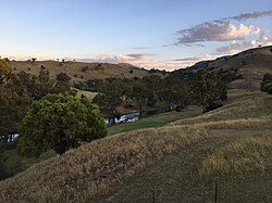
Goobarragandra River, a perennial stream[2] that is part of the Murrumbidgee catchment within the Murray–Darling basin, is located in the Snowy Mountains region of New South Wales, Australia. In the past, it was also known as Tumut Little River.[3]
- ^ "Map of Goobarragandra River". Bonzle.com. Retrieved 23 January 2013.
- ^ "Goobarragandra River". Geographical Names Register (GNR) of NSW. Geographical Names Board of New South Wales. Retrieved 22 January 2013.
- ^ "PROCLAMATION". New South Wales Government Gazette (Sydney, NSW : 1832 – 1900). 4 December 1897. p. 8809. Retrieved 19 March 2021.