Goodwood Heights | |
|---|---|
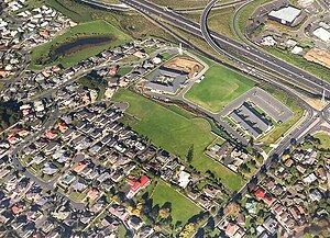
 Northern Goodwood Heights with the Auckland Southern Motorway in the background | |
 | |
| Coordinates: 36°59′38″S 174°53′58″E / 36.9939°S 174.8994°E | |
| Country | New Zealand |
| City | Auckland |
| Local authority | Auckland Council |
| Electoral ward | Manurewa-Papakura ward |
| Local board | Manurewa Local Board |
| Area | |
| • Land | 128 ha (316 acres) |
| Population (June 2024)[2] | |
• Total | 4,700 |
| Papatoetoe | Clover Park | Flat Bush |
| Manukau |
|
Totara Park |
| Wiri | Totara Heights | The Gardens |
Goodwood Heights is a suburb of Auckland, New Zealand. It is located approximately 20 kilometres southeast of the Auckland CBD; to the north of Totara Heights, east of Manukau Central and south of Chapel Downs. It was formerly part of Manukau City until the merger of all of Auckland's councils into the 'super city' in 2010.
Goodwood Heights is the location of St Johns Redoubt, a military camp established in 1863 during the Invasion of the Waikato. The suburb developed in the late 1970s, with Everglade Primary School established in the suburb in 1988. In 2020, construction began on Auckland New Zealand Temple, the second The Church of Jesus Christ of Latter-day Saints temple to be constructed in New Zealand.
- ^ Cite error: The named reference
Areawas invoked but never defined (see the help page). - ^ "Aotearoa Data Explorer". Statistics New Zealand. Retrieved 26 October 2024.