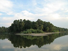
| Gornje Podunavlje | |
|---|---|
| Serbian Cyrillic: Горње Подунавље | |
IUCN category IV (habitat/species management area) | |
 Gornje Podunavlje near Apatin | |
| Location | Apatin, Sombor and Odžaci, Vojvodina, |
| Nearest city | Sombor |
| Coordinates | 45°45′50″N 18°55′34″E / 45.7639°N 18.9261°E |
| Area | 196.48 km2 (75.86 sq mi) |
| Established | 1955 2001 |
| www | |
| Designated | 13 November 2007 |
| Reference no. | 1737[1] |
Gornje Podunavlje Special Nature Reserve (Serbian: Специјални резерват природе Горње Подунавље, romanized: Specijalni rezervat prirode Gornje Podunavlje) is a large protected area of wetland in the northwest of Serbia (Vojvodina province), on the Danube's left bank. It comprises two large marshes, Monoštorski Rit and Apatinski Rit and vast forests, meadows, ponds, swamps and the Danube's meanders, including 66 km (41 mi) of the Danube course (1366 – 1433 km). It is a part of the trans-boundary biosphere reserve "Mura-Drava-Danube", a five country project, dubbed the "Amazon of Europe".[2][3]
The name means "Upper Danube Valley". Parts of the nature reserve are subject to the Croatia–Serbia border dispute; Croatia claims some areas under Serbian control on the eastern side of the river.
- ^ "Gornje Podunavlje". Ramsar Sites Information Service. Retrieved 25 April 2018.
- ^ Aleksandra Mijalković (28 May 2017), "Oživele šume i rukavci", Politika-Magazin No. 1026 (in Serbian), pp. 26–27
- ^ "A Transboundary Biosphere Reserve for the benefit of nature and people". 2017.
