| Gotthard Pass | |
|---|---|
| Italian: Passo del San Gottardo German: Gotthardpass | |
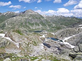
 The area of the Gotthard Pass from the west | |
| Elevation | 2,106 m (6,909 ft) |
| Traversed by |
|
| Location | Canton of Ticino, Switzerland (close to canton of Uri) |
| Range | Lepontine Alps |
| Coordinates | 46°33′22.5″N 8°34′04″E / 46.556250°N 8.56778°E |
| Topo map | Swiss Federal Office of Topography swisstopo |
Location in Switzerland (see detailed map) | |
The Gotthard Pass or St. Gotthard Pass (Italian: Passo del San Gottardo; German: Gotthardpass) at 2,106 m (6,909 ft) is a mountain pass in the Alps traversing the Saint-Gotthard Massif and connecting northern Switzerland with southern Switzerland. The pass lies between Airolo in the Italian-speaking canton of Ticino, and Andermatt in the German-speaking canton of Uri, and connects further Bellinzona and Lugano to Lucerne, Basel, and Zürich. The Gotthard Pass lies at the heart of the Gotthard, a major transport axis of Europe, and it is crossed by three traffic tunnels, each being the world's longest at the time of their construction: the Gotthard Rail Tunnel (1882), the Gotthard Road Tunnel (1980) and the Gotthard Base Tunnel (2016). With the Lötschberg to the west, the Gotthard is one of the two main north-south routes through the Swiss Alps.
Since the Middle Ages, transit across the Gotthard played an important role in Swiss history, the region north of the Gotthard becoming the nucleus of the Swiss Confederacy in the 13th century, after the pass became a vital trade route between Northern and Southern Europe.[1] The Gotthard is sometimes referred to as the "King of Mountain Passes" because of its central and strategic location.[2][3]
- ^ Anna Roos (2017). Swiss Sensibility: The Culture of Architecture in Switzerland. Birkhäuser. p. 6. ISBN 9783035609226.
For thousands of years the Gotthard Pass has been an important threshold between north and south Europe and for many centuries has played a significant role in the economy and culture of central Switzerland. Since the early thirteenth century, the pass has been a vital trade route connecting different cultures and language regions.
- ^ "Gotthard Pass Route: Airolo–San Gottardo–Andermatt". postauto.ch. PostBus Switzerland. Retrieved 23 February 2022.
The Gotthard, also known as the "King of Mountain Passes", is reached via the extraordinary mountain road with views of the old Tremola route.
- ^ Radaelli, Giulia; Thurn, Nike (2019). Gegenwartsliteratur - Weltliteratur: Historische und theoretische Perspektiven. Bielefeld: Transcript Verlag. p. 251. ISBN 9783839433652.
...zwischen 1218 und 1231 ansetzen könne, und just in jenen Interdezennien sei ja die Schöllenen bezwungen worden, die Teufelsbrücke gebaut und der König der Pässe, das royale Zentralalpenmassiv, dem Transitverkehr erschlossen worden...
[...could start between 1218 and 1231, and it was precisely in those interdecades that the Schöllenen was conquered, the Teufelsbrücke was built and the king of passes, the royal massif in the central Alps, was opened up to transit traffic...]
