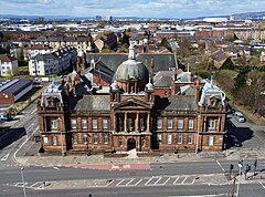
Govan
| |
|---|---|
 | |
Location within the Glasgow City council area Location within Scotland | |
| Area | 1.63 km2 (0.63 sq mi) [1] |
| Population | 5,860 (2015)[2] |
| • Density | 3,595/km2 (9,310/sq mi) |
| OS grid reference | NS555655 |
| • Edinburgh | 45 mi (72 km) E |
| • London | 346 mi (557 km) SSE |
| Council area | |
| Lieutenancy area |
|
| Country | Scotland |
| Sovereign state | United Kingdom |
| Post town | GLASGOW |
| Postcode district | G51 |
| Dialling code | 0141 |
| Police | Scotland |
| Fire | Scottish |
| Ambulance | Scottish |
| UK Parliament | |
| Scottish Parliament | |
Govan (/ˈɡʌvən/ GUV-ən; Cumbric: Gwovan;[3] Scots: Gouan; Scottish Gaelic: Baile a' Ghobhainn) is a district, parish, and former burgh now part of southwest Glasgow, Scotland. It is situated 2+1⁄2 miles (4 kilometres) west of Glasgow city centre, on the south bank of the River Clyde, opposite the mouth of the River Kelvin and the district of Partick. Historically it was part of the County of Lanark.
In the early medieval period, the site of the present Govan Old churchyard was established as a Christian centre for the Brittonic Kingdom of Alt Clut (Dumbarton Rock) and its successor realm, the Kingdom of Strathclyde. This latter kingdom, established in the aftermath of the Viking siege and capture of Alt Clut by Vikings from Dublin in 870, created the sandstone sculptures known today as the Govan Stones.
Govan was the site of a ford and later a ferry which linked the area with Partick for seasonal cattle drovers. In the eighteenth and nineteenth centuries, textile mills and coal mining were important; in the early-nineteenth century, shipbuilding emerged as Govan's principal industry.[4] In 1864, Govan gained burgh status, and was the fifth-largest burgh in Scotland. It was incorporated into the City of Glasgow in 1912.[5]
- ^ "statistics.gov.scot - Land Area (based on 2011 Data Zones)". statistics.gov.scot.
- ^ "statistics.gov.scot - Population Estimates (Current Geographic Boundaries)". statistics.gov.scot. Archived from the original on 25 April 2017. Retrieved 24 April 2017.
- ^ Clarkson, Tim (2014). Strathclyde and the Anglo-Saxons in the Viking Age. Edinburgh: John Donald. pp. 53–4, 54n.51. ISBN 978-1-906566-78-4.
- ^ "Scotland's Landscape: Govan". BBC. Retrieved 4 November 2018.
- ^ Reevel Alderson (7 August 2012). "How Glasgow annexed Govan and Partick 100 years ago". BBC News. Retrieved 8 August 2012.

