Govanhill
| |
|---|---|
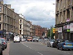
 Cathcart Road | |
Location within Glasgow | |
| Area | 0.86 km2 (0.33 sq mi) [1] |
| Population | 9,725 (2015)[1] |
| • Density | 11,308/km2 (29,290/sq mi) |
| OS grid reference | NS585628 |
| Council area | |
| Lieutenancy area |
|
| Country | Scotland |
| Sovereign state | United Kingdom |
| Post town | GLASGOW |
| Postcode district | G42 |
| Dialling code | 0141 |
| Police | Scotland |
| Fire | Scottish |
| Ambulance | Scottish |
| UK Parliament | |
| Scottish Parliament | |
Govanhill (Scottish Gaelic: Cnoc a' Ghobhainn) is an area of Glasgow, Scotland, situated south of the River Clyde between Pollokshields, the Gorbals, Strathbungo, Crosshill, Polmadie and Queen's Park. Historically part of Renfrewshire, Govanhill had the status of a police burgh between 1877 and 1891 before becoming part of the City of Glasgow. Since 2007, it has fallen under the Southside Central ward of Glasgow City Council. A previous (1999 to 2007) smaller ward named Govanhill had boundaries of Dixon Avenue and Dixon Road to the south, Victoria Road to the west, Butterbiggins Road to the north and Aikenhead Road to the east.[2]
- ^ a b - 2011 Intermediate Zone (Govanhill East and Aikenhead + Govanhill West) Archived 25 April 2017 at the Wayback Machine, Scottish Government Statistics, 2015
- ^ Electoral Arrangements for Local Government Areas in Scotland: Glasgow City Council Area, 3rd Reviews of Electoral Arrangements Maps, Wards 1999 - 2007 : Local Government Boundary Commission for Scotland
