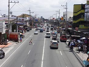
| Juanito R. Remulla Sr. Road | |
|---|---|
| Juanito Remulla Sr. Avenue Juanito Remulla Sr. Drive Governor's Drive | |
 Governor's Drive highlighted in red | |
 Governor's Drive between General Mariano Alvarez and Silang | |
| Route information | |
| Maintained by the Department of Public Works and Highways (DPWH) – Cavite 1st District Engineering Office, Cavite 2nd District Engineering Office, and Cavite Sub-District Engineering Office | |
| Length | 58.3 km (36.2 mi) |
| Existed | 1970s–present |
| Component highways | |
| Major junctions | |
| East end | Carmona Bridge on the Carmona–Biñan boundary |
| |
| West end | |
| Location | |
| Country | Philippines |
| Provinces | Cavite |
| Major cities | Carmona, Dasmariñas, General Trias, Trece Martires |
| Towns | General Mariano Alvarez, Silang, Tanza, Naic, Maragondon, Ternate |
| Highway system | |
| |
The Juanito R. Remulla Sr. Road,[a] formerly and still commonly referred to as Governor's Drive, is a two-to-nine lane, 58.3-kilometer (36.2 mi) network of primary, secondary and tertiary highways and bridges traversing through the central cities and municipalities of the province of Cavite, Philippines.[1][2][3] It is the widest among the three major highways located in the province, the others being the Aguinaldo and Antero Soriano Highways.
The road forms part of National Route 65 (N65), National Route 651 (N651), National Route 403 (N403), and National Route 405 (N405) of the Philippine highway network. A part of the road between the N403 and N405 section is a tertiary road and is unnumbered.
Cite error: There are <ref group=lower-alpha> tags or {{efn}} templates on this page, but the references will not show without a {{reflist|group=lower-alpha}} template or {{notelist}} template (see the help page).
- ^ "Cavite". Department of Public Works and Highways. Archived from the original on January 9, 2018. Retrieved September 19, 2018.
- ^ "Cavite 2nd". Department of Public Works and Highways. Archived from the original on October 1, 2018. Retrieved September 19, 2018.
- ^ "Cavite Sub". Department of Public Works and Highways. Archived from the original on October 2, 2018. Retrieved September 19, 2018.


