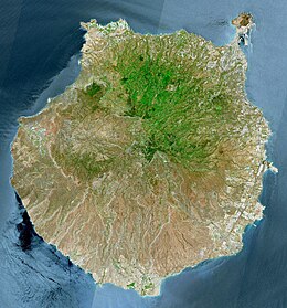
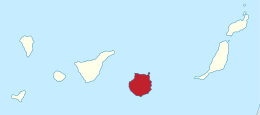
 Gran Canaria (April 2023) | |
 | |
| Geography | |
|---|---|
| Location | Atlantic Ocean |
| Coordinates | 27°58′N 15°36′W / 27.967°N 15.600°W |
| Area | 1,560.11 km2 (602.36 sq mi) |
| Highest elevation | 1,956 m (6417 ft) |
| Highest point | Morro de la Agujereada |
| Spain | |
| Region | Macaronesia |
| Autonomous Community | Canary Islands |
| Province | Las Palmas |
| Largest settlement | Las Palmas de Gran Canaria (pop. 380,863) |
| Demographics | |
| Population | 862,893[1] (start of 2023) |
| Pop. density | 553.1/km2 (1432.5/sq mi) |

Gran Canaria (UK: /ˌɡræn kəˈnɛəriə, -ˈnɑːr-/, US: /ˌɡrɑːn kəˈnɑːriə, -ˈnɛər-/;[2][3] Spanish: [ɡɾaŋ kaˈnaɾja] ), also Grand Canary Island, is the third-largest and second-most-populous island of the Canary Islands,[4] an archipelago off the Atlantic coast of Northwest Africa and is part of Spain. As of 2023[update] the island had a population of 862,893 that constitutes approximately 40% of the population of the archipelago. Las Palmas de Gran Canaria, the capital of the island, is the biggest city of the Canary Islands and the ninth of Spain.
Gran Canaria is located in the Atlantic Ocean in a region known as Macaronesia about 150 kilometres (93 mi) off the northwestern coast of Africa and about 1,350 km (840 mi) from Europe.[5] With an area of 1,560 km2 (600 sq mi)[6] and an altitude of 1,956 m (6,417 ft) at Morro de la Agujereada, Gran Canaria is the third largest island of the archipelago in both area and altitude. Gran Canaria is also the third most populated island in Spain.[7]
- ^ Population referred to the January 1, 2019 Archived 31 January 2019 at the Wayback Machine
- ^ Wells, John C. (2008). Longman Pronunciation Dictionary (3rd ed.). Longman. ISBN 978-1-4058-8118-0.
- ^ Roach, Peter (2011). Cambridge English Pronouncing Dictionary (18th ed.). Cambridge: Cambridge University Press. ISBN 978-0-521-15253-2.
- ^ Population referred to the January 1, 2018 Archived 31 January 2019 at the Wayback Machine
- ^ Situación y Clima. Ayuntamiento de Las Palmas de Gran Canaria. Archived 29 June 2010 at the Wayback Machine
- ^ ISTAC: Estadísticas de la Comunidad Autónoma de Canarias Archived 14 November 2010 at the Wayback Machine (Statistics for the Canaries) on gobiernodecanarias.org.
- ^ "Boletín Oficial del Estado" (PDF). 29 December 2018.