Grand-Remous | |
|---|---|
 | |
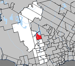
 Location within La Vallée-de-la-Gatineau RCM. | |
| Coordinates: 46°37′N 75°54′W / 46.617°N 75.900°W[1] | |
| Country | Canada |
| Province | Quebec |
| Region | Outaouais |
| RCM | La Vallée-de-la-Gatineau |
| Constituted | April 29, 1937 |
| Government | |
| • Mayor | Jocelyne Lyrette |
| • Federal riding | Pontiac |
| • Prov. riding | Gatineau |
| Area | |
| • Total | 509.89 km2 (196.87 sq mi) |
| • Land | 351.63 km2 (135.77 sq mi) |
| Population (2021)[3] | |
| • Total | 1,159 |
| • Density | 3.3/km2 (9/sq mi) |
| • Pop (2016–21) | |
| • Dwellings | 778 |
| Time zone | UTC−5 (EST) |
| • Summer (DST) | UTC−4 (EDT) |
| Postal code(s) | |
| Area code | 819 |
| Website | www |
Grand-Remous is a town and municipality in La Vallée-de-la-Gatineau Regional County Municipality, Quebec, Canada. The municipality is south of the Baskatong Reservoir, spanning both sides of the Gatineau River. The town is situated at the intersection of Route 117 and Route 105.
"Grand-Remous" is French for "great eddy" and is a reference to a large whirlpool on the Gatineau River near the Grand Remous Chute. This name matches the Atikamekw name "Obémiticwang", also meaning "choppy waters" or "big stir."[4]
Its territory consists of low hills which vary between 200 meters (660 ft) and 380 meters (1,250 ft) above sea level, and which are partly cleared, mostly around Grand-Remous and along highway 105.[5]
- ^ Cite error: The named reference
toponymiewas invoked but never defined (see the help page). - ^ a b "Répertoire des municipalités: Geographic code 83095". www.mamh.gouv.qc.ca (in French). Ministère des Affaires municipales et de l'Habitation.
- ^ a b Cite error: The named reference
sc2021was invoked but never defined (see the help page). - ^ "Municipalité de Canton de Grand-Remous" (in French). Commission de toponymie du Québec. Archived from the original on 2016-03-03. Retrieved 2008-08-05.
- ^ "Canton de Sicotte" (in French). Commission de toponymie du Québec. Archived from the original on 2016-03-03. Retrieved 2008-08-05.
