Grand Village of the Natchez | |
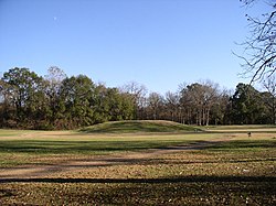
 Main mound at the Grand Village of the Natchez Site in Natchez, Mississippi | |
| Nearest city | 400 Jefferson Davis Boulevard, Natchez, Mississippi |
|---|---|
| Coordinates | 31°31′31″N 91°22′54″W / 31.525205°N 91.381638°W |
| NRHP reference No. | 66000408 |
| Significant dates | |
| Added to NRHP | October 15, 1966[2] |
| Designated NHL | July 19, 1964[3] |
| Designated USMS | May 9, 1985[1] |
Grand Village of the Natchez (22 AD 501), also known as the Fatherland Site, is a 128.1-acre (0.518 km2) site encompassing a prehistoric indigenous village and earthwork mounds in present-day south Natchez, Mississippi. The village complex was constructed starting about 1200 CE by members of the prehistoric Plaquemine culture. They built the three platform mounds in stages. Another phase of significant construction work by these prehistoric people has been dated to the mid-15th century. It was named for the historic Natchez people, who used the site in the 17th and 18th centuries.[4]
In the early 18th century, when the historic Natchez people occupied the site, they added to the mounds.[4][5]
The village was the Natchez tribe's main political and religious ceremonial center in the late 17th and early 18th centuries, according to historical and archaeological evidence.[6] It replaced the Emerald Mound site in this role. After suffering a military defeat by French settlers in 1730, the Natchez abandoned the site and moved away.[4] In the early 19th century, the land was privately owned and cultivated as part of the Fatherland Plantation. Archaeological excavations started in 1930, and three mounds were found. (They had been partially buried by loess soils, with some erosion due to St. Catherine's Creek.)
The site was declared a National Historic Landmark in 1964[3][4] and a Mississippi Landmark in 1985.[1] The site is listed on the Mississippi Mound Trail.[7]
- ^ a b "Mississippi Landmarks" (PDF). Mississippi Department of Archives and History. May 2008. Archived from the original (PDF) on October 9, 2010. Retrieved April 20, 2009.
- ^ "National Register Information System". National Register of Historic Places. National Park Service. January 23, 2007.
- ^ a b "Grand Village of the Natchez". National Historic Landmark summary listing. National Park Service. Archived from the original on June 6, 2011. Retrieved October 20, 2007.
- ^ a b c d Francine Weiss and Mark R. Barnes (May 3, 1989). "National Register of Historic Places Registration: Grand Village of the Natchez Site / Fatherland Plantation Site (22-Ad-501)" (pdf). National Park Service.
{{cite journal}}: Cite journal requires|journal=(help) and Accompanying 3 photos, from 1989. (680 KB) - ^ "Natchez Indians". Mississippi Historical Society. October 2007. Archived from the original on February 24, 2009. Retrieved April 20, 2009.
- ^ "Grand Village of the Natchez Indians". Mississippi Department of Archives and History. Archived from the original on April 13, 2009. Retrieved April 20, 2009.
- ^ "Mississippi Mound Trail". Mississippi Department of Archives and History. Archived from the original on July 9, 2021. Retrieved July 13, 2021.

