| Grapevine Lake | |
|---|---|
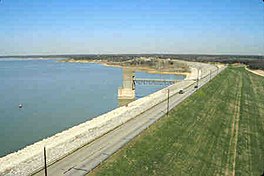
 The reservoir's earthen dam | |
 Reservoir and its parks | |
| Location | Denton / Tarrant counties, North Texas, United States |
| Coordinates | 32°58′20″N 97°3′24″W / 32.97222°N 97.05667°W |
| Type | Reservoir |
| Primary inflows | Denton Creek |
| Primary outflows | Denton Creek |
| Basin countries | Texas, United States |
| Surface area | 7,280 acres (2,950 ha) |
| Max. depth | 65 ft (20 m) |
| Water volume | 181,100 acre⋅ft (0.2234 km3) |
| Shore length1 | 60 miles (97 km) |
| Surface elevation | 535 ft (163 m) |
| Settlements | Grapevine, Texas |
| 1 Shore length is not a well-defined measure. | |
Grapevine Lake is a reservoir in North Texas about 20 mi (32 km) northwest of Dallas and northeast of Fort Worth. It was impounded in 1952 by the U.S. Army Corps of Engineers when they dammed Denton Creek, a tributary of Trinity River.
The reservoir's primary purposes are flood control and to act as a municipal water reservoir, with a secondary function of providing recreation and open-space areas. The lake's name comes from the city of Grapevine, Texas, to which the lake is adjacent.


