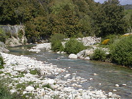
| Gravona | |
|---|---|
 Upper Gravona | |
| Physical characteristics | |
| Source | |
| • location | Monte Renoso |
| • elevation | 1,700 m (5,600 ft) (approx.) |
| Mouth | Mediterranean Sea |
• location | Near Ajaccio |
• coordinates | 41°54′17″N 8°47′54″E / 41.90472°N 8.79833°E |
• elevation | 0 m (0 ft) |
| Length | 46.4 km (28.8 mi) |
| Basin size | 298.98 km2 (115.44 sq mi)[1] |
| Discharge | |
| • average | 0 to very low |
The Gravona is a river on the island of Corsica, France. It flows from the center of the island southwest to the Gulf of Ajaccio. Its entire course is in the Corse-du-Sud Department of France. It is 46.4 km (28.8 mi) long.[2] The Gravona Valley conducts the main highway, Route N193, from the capital city, Ajaccio, to the Col de Vizzavona, where it goes through the pass and down to Corte and Bastia. At its upper end the Gravona is a crystal-clear mountain stream cascading over falls and rapids into trout-filled pools. At its lower end nearly all of the Gravona's flow serves to water the densely urban area of Ajaccio.
- ^ Reclus, Onésime (1899). Le plus beau royaume sous le ciel (in French). Hachette. p. 727.. Downloadable Google Books.
- ^ Sandre. "Fiche cours d'eau - La Gravona (Y83-0400)".

