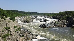
| Great Falls | |
|---|---|
 The Great Falls as seen from Northern Virginia | |
 | |
| Location | Montgomery County, Maryland and Fairfax County, Virginia, U.S. |
| Coordinates | 38°59′51″N 77°15′09″W / 38.99750°N 77.25250°W |
| Type | Steep Tiered Cascades |
| Elevation | 129 ft (39 m) |
| Total height | 47 ft (14 m) [1] |
| Average width | 350 ft (110 m) [1] |
| Run | 550 ft (170 m) [1] |
| Watercourse | Potomac River |
| Average flow rate | 16,750 cu ft/s (474 m3/s) (est.) [1] |
Great Falls is a series of rapids and waterfalls on the Potomac River, 14 miles (23 km) upstream from Washington, D.C., on the border of Montgomery County, Maryland and Fairfax County, Virginia. The Potomac and the falls themselves are legally entirely within Maryland, since the state's border follows the south bank of the river.
Great Falls Park, managed as part of George Washington Memorial Parkway, is on the southern banks in Virginia, and Chesapeake and Ohio Canal National Historical Park parkland is along the northern banks of the river in Maryland. Both are operated by the National Park Service.
The Great Falls area is popular for outdoor activities such as kayaking, whitewater rafting, rock climbing, and hiking. The Billy Goat Trail on Bear Island, and Olmsted Island, both accessible from Maryland, offer scenic views of the Great Falls. There also are overlook points on the Virginia side.
Great Falls and Little Falls (about 5 miles downstream) are named in contradistinction to one another.
- ^ a b c d "Great Falls, Maryland, United States - World Waterfall Database". www.worldwaterfalldatabase.com. Retrieved 2020-01-17.