| Great Kei River Groot-Keirivier | |
|---|---|
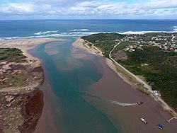
 Aerial photograph of the mouth of the Great Kei River as it meets the Indian Ocean. The river ferry allowing vehicles and passengers to cross the river can be seen in the foreground. | |
 | |
| Etymology | From kei, the word for "water" in the Khoekhoe language |
| Location | |
| Country | South Africa |
| Province | Eastern Cape Province |
| Physical characteristics | |
| Source | Stormberg Mountains |
| • location | Eastern Cape, South Africa |
| • elevation | 1,500 m (4,900 ft) |
| Source confluence | Swart-Kei / Wit-Kei |
| • coordinates | 32°13′34″S 27°30′36″E / 32.22611°S 27.51000°E |
| • elevation | 540 m (1,770 ft) |
| Mouth | Indian Ocean |
• location | By Kei Mouth, South Africa |
• coordinates | 32°40′34″S 28°22′51″E / 32.67611°S 28.38083°E |
• elevation | 0 m (0 ft) |
| Length | 320 km (200 mi) |
| Basin features | |
| Tributaries | |
| • left | Xolobe |
| • right | Kubusi |
The Great Kei River is a river in the Eastern Cape province of South Africa. It is formed by the confluence of the Black Kei River and White Kei River, northeast of Cathcart. It flows for 320 km (199 mi)[1] and ends in the Great Kei Estuary at the Indian Ocean with the small town Kei Mouth on the west bank. Historically the Great Kei River formed the southwestern border of the Transkei region as was formerly known as the Nciba River.
- ^ SA Estuarine Land-cover: Great Kei Catchment Archived 2004-12-27 at the Wayback Machine
